Clearwell Meend is a small area just up from the village of Clearwell, it surrounds the site of Clearwell Caves. It is not woodland pure and simple but it does have a lot of trees, but there are also open grassland areas and a lot of little ponds.![]()
I have visited it many times as it is only 1 minute walk from where I live. I have written several blogs about it and photographed flowers, butterflies and birds that occur there.
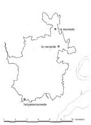 I have often wondered about the name Meend, it was not something I had come across before I came to Gloucestershire. However in Gloucestershire there are several Meends, close to here we have Staunton Meend. There are mixed opinions about the origin, one is that it is derived from Old Welsh ‘minid’, meaning mountain but that is not so popular. The other is from the Anglo Saxon word Munede. The first use of this word appears on a map from 1282.
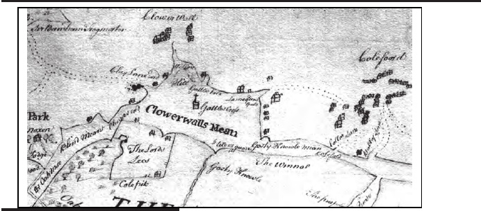
There is also a map of Clearwell Meend from 1682. Incidental Clearwell comes from ‘clower’ meaning Clover and well is a fresh water spring. So it was a place where there was a spring in a place where a lot of Clover grew. Please note the area marked as Clearwell meend on the map below obviously represents its size back in 1682. Today it is just the final remnant of what was quite a large area in those days.
Here is a link to an extensive article about Meends called ‘The Meaning and origin of Meends in the Forest of Dean’ This is an extract from the text.
‘In its earliest reference is known as le Meoned in 1375 by which time it already formed the boundary of the Forest. It is known as Clorwelmende in 1395 and in 1427 as Clorewalusmende. By 1682 it was known as Clowerwalls Mean and the Drivers referred to it as Clearwell Meend in 1787. It was significant enough to feature on Isaac Taylor’s map of 1777 where it is noted simply as Meend . In later maps the extent of this meend was shown to spread along the fringe of the forest as far north as Coverham. Parts of it were known as Gorsty Knowle Mean in 1682 and Coleford Meend from the late eighteenth century onwards.‘

In the centre of the area there is a standing stone which, as I was told by the former owner of Clearwell Caves is approximately at the intersection of some ‘Ley lines’ He told me that there had always been one there or there about’s but that it had been destroyed by Christians in the past as it represented a pagan belief. He had then re erected the present stone. It is interesting to note that on the above map there is a symbol of a cross on top of a square and it is more or less where the present standing stone is. Or it could be where there is little church which is at the top of Clearwell, though I believe the present church was built somewhat later than 1682.
Anyway whatever the derivation it means a sort of waste place in the Forest, a bit like a Common, and no doubt was used in a similar way in the past, ie for locals to graze their animals, collecting wood, mainly for fuel and as a place to collect food.
Clearwell Meend has an interesting feature in that lower down close to the village of Clearwell the soil is alkaline and plants like Eyebright, Salad Burnett, Ploughmans Spikenard and Autumn Gentian are found but higher up it becomes acidic and plants like Calluna Erica and Sorrell occur.
In terms of woodland species, there are some Bluebells and Primrose and I have also seen False Oxlip, Dogs Mercury and even some Solomon’s Seal but I suspect that was an escape…..
Here are some links to other things I have written on this subject
and finally a few photos of the area, as you can see there are quite a lot of trees, there is an enormous pollarded Willow near the top and recently there has been a lot of clearance work to prevent the entire area becoming covered with young trees.
I have read that the orchid Autumn lady’s-tresses grows there but I have never seen them. I have seen Common Spotted Orchid, Twayblade, Bee Orchid and Pyramidal orchids.
